
Fail:Jahreszeiten Jahresringe.jpg
Shi nwuana̱son huni:a̱yaapixel 600 × 600 Ngyong ghyáng: a̱yaapixel 240 × 240 | a̱yaapixel 480 × 480 | a̱yaapixel 768 × 768 | a̱yaapixel 1,024 × 1,024 | a̱yaapixel 2,497 × 2,497.
A̱tsatsak fail (A̱yaapixel 2,497 × 2,497, shi fail: 3.4 MB, kak MIME: image/jpeg)
Nam-a̱lyiat
| Wa̱i a̱lyiat |
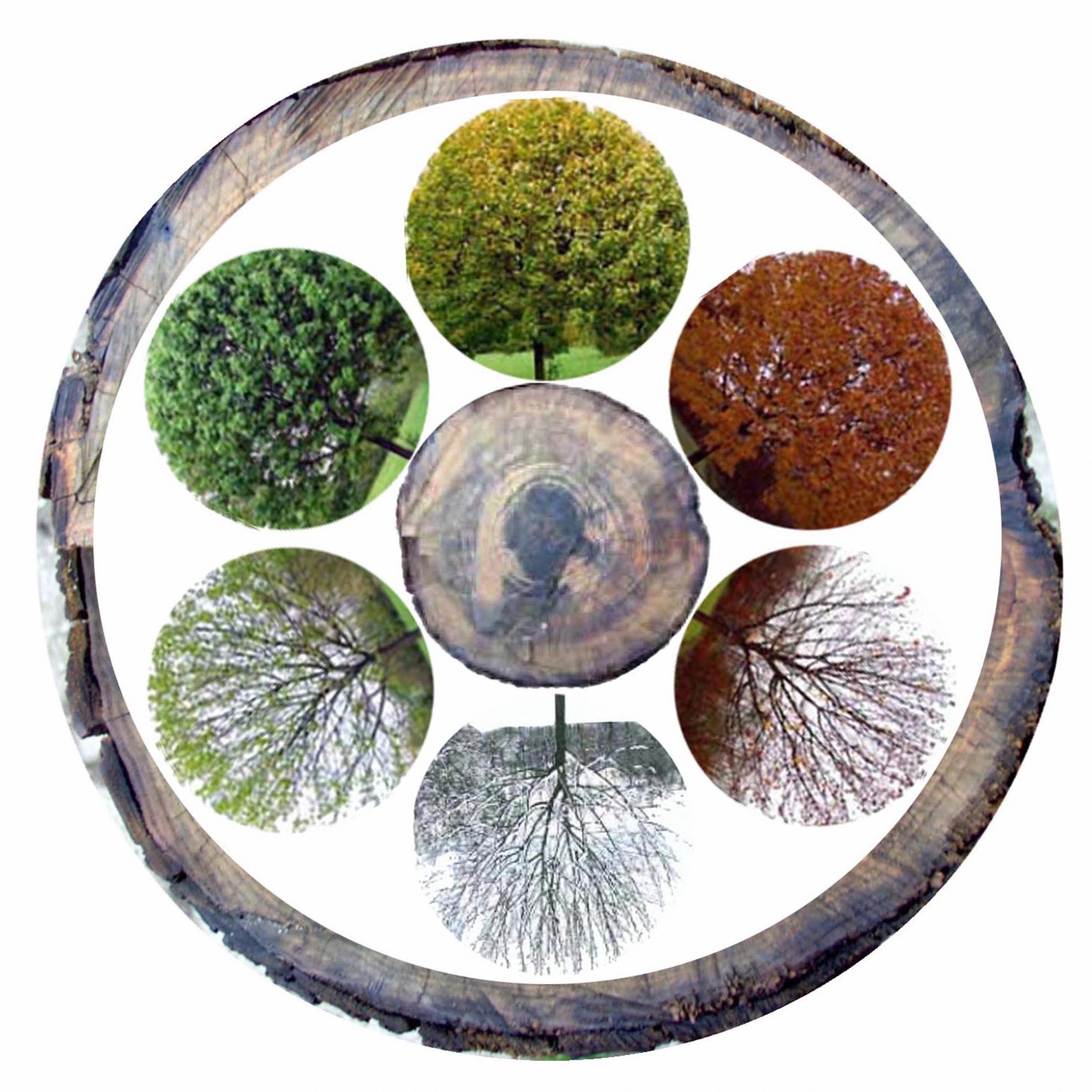
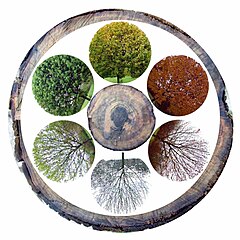
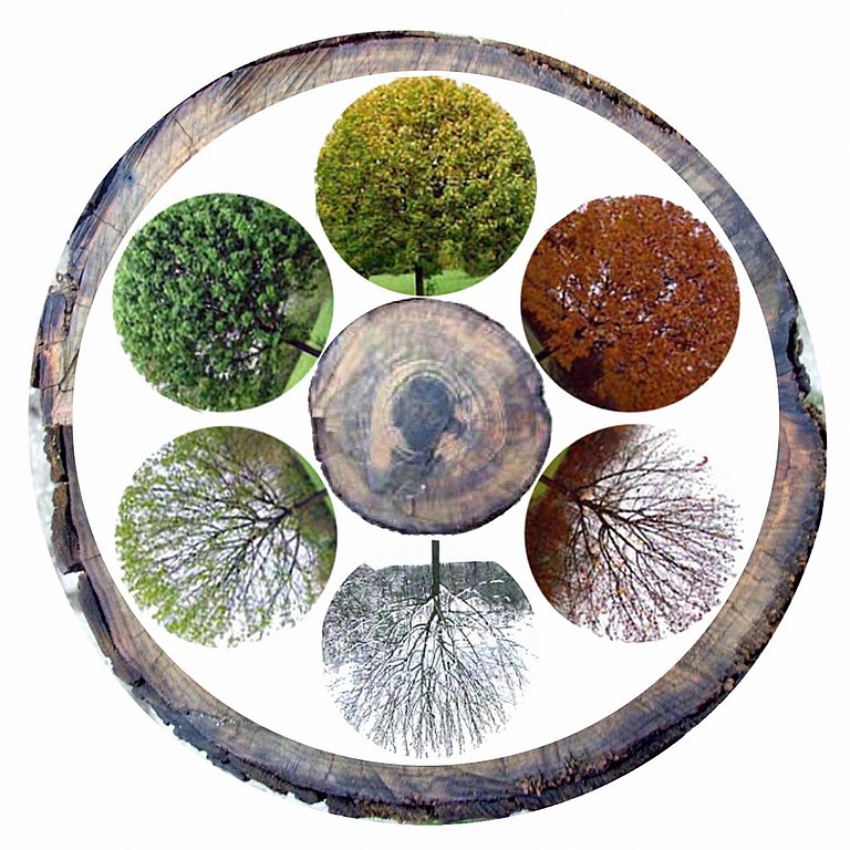
English: Seasons /Annual rings The six ecological seasons. From bottom, clockwise: prevernal, vernal, estival, serotinal, autumnal, hibernal Deutsch: Jahreszeiten / Jahresring |
| A̱tuk | |
| A̱tyin | Ta̱m a̱pyia̱ nung hwa |
| A̱tyulyuut | Meinolf Wewel |
Shyiat kwaa̱mbwat a̱ka̱wat
I, the copyright holder of this work, hereby publish it under the following license:
Á̱ nwuak fail huni a̱tafa kwambwat a̱ka̱wat Creative Commons A̱di̱dam Kaswuo 3.0 Unported hu hwa.
- A byia̱ sa̱t:
- ka̱ a cat ka̱u – ka̱ a cat maat, ka̱u ma̱ng shei ta̱m hu
- ka̱ a cat nyia̱ ri̱mik – ka̱ a cat saai ta̱m hu
- A̱tafa ta̱fwat ji̱ khwi a̱ni:
- a̱di̱dam kaswuo – Ta hwa a nwuak a̱gwai ku myim a̱ni, tyia̱ a̱fwuop kwaa̱mbwat a̱ka̱wat ka, a si̱ wa̱i ka̱ á̱ ku shai kyang mami. A bye nyia̱ a̱nia di̱ kuzang za̱kwa ji̱ myim a̱ni, a̱wot tyong nyian hu si̱sak ji̱ na li á ngyei a̱tyunwuat kwaa̱mbwat a̱ka̱wat wu wa shim ang ku da̱ nggu wa shim nyian ta̱m ang hu a̱ni.
| Annotations | This image is annotated: View the annotations at Commons |
Nkhang fail
Nyap a̱tuk/jen a nwuan fail hu ma̱nang ku ku ndi di̱ ntsa hu mi̱ di̱n jen a̱ja.
| A̱tuk/Jen | A̱gban ghwughwu | Shi-a̱ka̱ta̱m | A̱tyunta̱m | A̱di̱dam | |
|---|---|---|---|---|---|
| mi̱ di̱ yong huni | 02:00, 6 Zwat Tswuon 2018 | | 2,497 × 2,497 (3.4 MB) | Hohum | Cropped |
| 19:55, 12 Zwat Swak 2012 |  | 2,953 × 2,953 (4.17 MB) | Meinolf Wewel | {{Information |Description ={{en|1=Seasons /Annual rings}} {{de|1=Jahreszeiten / Jahresring}} |Source ={{own}} |Author =Meinolf Wewel |Date =19.03.2006 |Permission = |other_versions = }} [[Catego... |
Nyian ta̱m ma̱ng fail
Wat huni nyia̱ ta̱m ma̱ng fail huni:
Nyian ta̱m ma̱ng fail mi̱ swanta hu a̱mgba̱m
A̱yaawuki á̱ghyang bani nyia̱ ta̱m ma̱ng fail huni:
- Nyian ta̱m di̱ af.wikipedia.org
- Nyian ta̱m di̱ ar.wikipedia.org
- Nyian ta̱m di̱ ast.wikipedia.org
- Nyian ta̱m di̱ bh.wikipedia.org
- Nyian ta̱m di̱ br.wikipedia.org
- Nyian ta̱m di̱ cs.wikipedia.org
- Nyian ta̱m di̱ da.wikipedia.org
- Nyian ta̱m di̱ de.wikipedia.org
- Nyian ta̱m di̱ dty.wikipedia.org
- Nyian ta̱m di̱ en.wikipedia.org
- Aridity
- World Climate Programme
- Surface Ocean Lower Atmosphere Study
- Mesothermal
- Megathermal
- Interdecadal Pacific oscillation
- Polar High
- Icelandic Low
- EdGCM
- International Programme for Antarctic Buoys
- Pluvial
- Moisture recycling
- Transient climate simulation
- Salt storm
- MIT General Circulation Model
- Land surface models (climate)
- Canadian Land Surface Scheme
- Baseline Surface Radiation Network
- Intermediate General Circulation Model
- Okhotsk High
- VAMOS Ocean-Cloud-Atmosphere-Land Study
- Pacific–North American teleconnection pattern
- Global Land Project
- Tundra climate
- Maritime Continent
- Norwegian-U.S. Scientific Traverse of East Antarctica
- South Pacific High
- Spatial Synoptic Classification system
- GrADS
- Regional climate levels in viticulture
- HadGEM1
- South Atlantic Convergence Zone
- Season
- Climograph
- GO-ESSP
- North Pacific High
- North Pacific Oscillation
- Tropical Warm Pool
- Model year (computer modeling)
- Colorado low
Li nvak jhyang nang á̱ nyian ta̱m mi̱ swanta hu ma̱ng fail huni.