
Fail:Lakechad map.png
Lakechad_map.png (A̱yaapixel 588 × 362, shi fail: 38 KB, kak MIME: image/png)
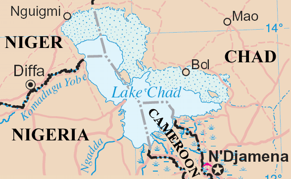
Lake Chad and surrounding area
Map adapted from http://www.un.org/Depts/Cartographic/map/profile/niger.pdf
| This image is a map derived from a United Nations map.
Unless stated otherwise, UN maps are to be considered in the public domain. This applies worldwide. UN maps are, in principle, open source material and you can use them in your work or for making your own map. UN requests however that you delete the UN name, logo and reference number upon any modification to the map. Content of your map will be your responsibility. You can state in your publication, if you wish, something like: based on UN map … (map name, map number, revision number and date). See: Geospatial Information Section. And: Geospatial, location data for a better world. |
 |
Nkhang fail
Nyap a̱tuk/jen a nwuan fail hu ma̱nang ku ku ndi di̱ ntsa hu mi̱ di̱n jen a̱ja.
| A̱tuk/Jen | A̱gban ghwughwu | Shi-a̱ka̱ta̱m | A̱tyunta̱m | A̱di̱dam | |
|---|---|---|---|---|---|
| mi̱ di̱ yong huni | 17:20, 23 Zwat Tswuon 2006 | | 588 × 362 (38 KB) | Amcaja | Lake Chad and surrounding area Map adapted from http://www.un.org/Depts/Cartographic/map/profile/niger.pdf {{UN map}} Category:Maps Category:Maps of Cameroon |
Nyian ta̱m ma̱ng fail
Wat huni nyia̱ ta̱m ma̱ng fail huni:
Nyian ta̱m ma̱ng fail mi̱ swanta hu a̱mgba̱m
A̱yaawuki á̱ghyang bani nyia̱ ta̱m ma̱ng fail huni:
- Nyian ta̱m di̱ af.wikipedia.org
- Nyian ta̱m di̱ an.wikipedia.org
- Nyian ta̱m di̱ ar.wikipedia.org
- Nyian ta̱m di̱ bn.wikipedia.org
- Nyian ta̱m di̱ cy.wikipedia.org
- Nyian ta̱m di̱ el.wikipedia.org
- Nyian ta̱m di̱ en.wikipedia.org
- Nyian ta̱m di̱ es.wikipedia.org
- Nyian ta̱m di̱ fa.wikipedia.org
- Nyian ta̱m di̱ fi.wikipedia.org
- Nyian ta̱m di̱ fr.wikipedia.org
- Nyian ta̱m di̱ fy.wikipedia.org
- Nyian ta̱m di̱ he.wikipedia.org
- Nyian ta̱m di̱ hr.wikipedia.org
- Nyian ta̱m di̱ id.wikipedia.org
- Nyian ta̱m di̱ incubator.wikimedia.org
- Nyian ta̱m di̱ io.wikipedia.org
- Nyian ta̱m di̱ ja.wikipedia.org
- Nyian ta̱m di̱ ka.wikipedia.org
- Nyian ta̱m di̱ ko.wikipedia.org
- Nyian ta̱m di̱ la.wikipedia.org
- Nyian ta̱m di̱ lb.wikipedia.org
- Nyian ta̱m di̱ lt.wikipedia.org
- Nyian ta̱m di̱ mg.wikipedia.org
- Nyian ta̱m di̱ mn.wikipedia.org
- Nyian ta̱m di̱ ms.wikipedia.org
- Nyian ta̱m di̱ mt.wikipedia.org
- Nyian ta̱m di̱ my.wikipedia.org
- Nyian ta̱m di̱ nds-nl.wikipedia.org
- Nyian ta̱m di̱ nl.wikipedia.org
- Nyian ta̱m di̱ no.wikipedia.org
- Nyian ta̱m di̱ oc.wikipedia.org
- Nyian ta̱m di̱ pa.wikipedia.org
- Nyian ta̱m di̱ pt.wikipedia.org
- Nyian ta̱m di̱ qu.wikipedia.org
- Nyian ta̱m di̱ ro.wikipedia.org
- Nyian ta̱m di̱ sc.wikipedia.org
- Nyian ta̱m di̱ sh.wikipedia.org
- Nyian ta̱m di̱ simple.wikipedia.org
- Nyian ta̱m di̱ si.wikipedia.org
- Nyian ta̱m di̱ sk.wikipedia.org
- Nyian ta̱m di̱ sl.wikipedia.org
Li nvak jhyang nang á̱ nyian ta̱m mi̱ swanta hu ma̱ng fail huni.