
Fail:North America satellite orthographic.jpg

Shi nwuana̱son huni:a̱yaapixel 557 × 600 Ngyong ghyáng: a̱yaapixel 223 × 240 | a̱yaapixel 446 × 480 | a̱yaapixel 713 × 768 | a̱yaapixel 951 × 1,024 | a̱yaapixel 1,624 × 1,748.
A̱tsatsak fail (A̱yaapixel 1,624 × 1,748, shi fail: 474 KB, kak MIME: image/jpeg)
Nam-a̱lyiat
| Wa̱i a̱lyiat |
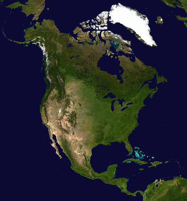
English: A composite satellite photograph of North America. The observer is centered at (40° N, 95° W), at Moon distance above the Earth.
Español: Imagen de satélite de América del Norte
|
| A̱tuk | "Blue Marble" image, 2002; this projection, 2005 |
| A̱tyin | This is NASA image applied as a texture on a sphere using program. |
| A̱tyulyuut | NASA |
|
Shyiat kwaa̱mbwat a̱ka̱wat
| This file is in the public domain in the United States because it was solely created by NASA. NASA copyright policy states that "NASA material is not protected by copyright unless noted". (See Template:PD-USGov, NASA copyright policy page or JPL Image Use Policy.) | ||
 |
Warnings:
|
Nkhang fail
Nyap a̱tuk/jen a nwuan fail hu ma̱nang ku ku ndi di̱ ntsa hu mi̱ di̱n jen a̱ja.
| A̱tuk/Jen | A̱gban ghwughwu | Shi-a̱ka̱ta̱m | A̱tyunta̱m | A̱di̱dam | |
|---|---|---|---|---|---|
| mi̱ di̱ yong huni | 11:07, 19 Zwat Nyaai 2005 | | 1,624 × 1,748 (474 KB) | Ghalas | A composed satellite photograph of North America in orthographic projection This is NASA [http://visibleearth.nasa.gov/view_rec.php?vev1id=11656 "Blue Marble"] image applied as a texture |
Nyian ta̱m ma̱ng fail
Wat huni nyia̱ ta̱m ma̱ng fail huni:
Nyian ta̱m ma̱ng fail mi̱ swanta hu a̱mgba̱m
A̱yaawuki á̱ghyang bani nyia̱ ta̱m ma̱ng fail huni:
- Nyian ta̱m di̱ ace.wikipedia.org
- Nyian ta̱m di̱ ady.wikipedia.org
- Nyian ta̱m di̱ af.wikipedia.org
- Nyian ta̱m di̱ als.wikipedia.org
- Nyian ta̱m di̱ anp.wikipedia.org
- Nyian ta̱m di̱ ar.wikipedia.org
- Nyian ta̱m di̱ ary.wikipedia.org
- Nyian ta̱m di̱ arz.wikipedia.org
- Nyian ta̱m di̱ ast.wikipedia.org
- Nyian ta̱m di̱ az.wikipedia.org
- Nyian ta̱m di̱ bat-smg.wikipedia.org
- Nyian ta̱m di̱ ba.wikipedia.org
- Nyian ta̱m di̱ be-tarask.wikipedia.org
- Nyian ta̱m di̱ be.wikipedia.org
- Nyian ta̱m di̱ bg.wikipedia.org
- Nyian ta̱m di̱ bjn.wikipedia.org
- Nyian ta̱m di̱ br.wikipedia.org
- Nyian ta̱m di̱ ca.wikipedia.org
- Nyian ta̱m di̱ ceb.wikipedia.org
- Nyian ta̱m di̱ crh.wikipedia.org
- Nyian ta̱m di̱ cs.wikipedia.org
- Nyian ta̱m di̱ cy.wikipedia.org
- Nyian ta̱m di̱ da.wikipedia.org
- Nyian ta̱m di̱ da.wikibooks.org
- Nyian ta̱m di̱ de.wikipedia.org
- Nyian ta̱m di̱ diq.wikipedia.org
- Nyian ta̱m di̱ dsb.wikipedia.org
- Nyian ta̱m di̱ el.wikipedia.org
- Nyian ta̱m di̱ en.wikipedia.org
Li nvak jhyang nang á̱ nyian ta̱m mi̱ swanta hu ma̱ng fail huni.