
Fail:Palau - Location Map (2013) - PLW - UNOCHA.svg

A̱tsatsak fail (Fail SVG, a̱yaapixel 250 × 250 mi̱ taada, shi fail: 1.12 MB)
_-_PLW_-_UNOCHA.svg)
Nam-a̱lyiat
| Wa̱i a̱lyiat |
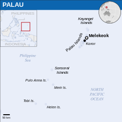
English: Locator map of Palau. |
| A̱tuk | |
| A̱tyin |
English: Palau Locator Map (ReliefWeb) |
| A̱tyulyuut | |
| SVG genesis |
Shyiat kwaa̱mbwat a̱ka̱wat
- A byia̱ sa̱t:
- ka̱ a cat ka̱u – ka̱ a cat maat, ka̱u ma̱ng shei ta̱m hu
- ka̱ a cat nyia̱ ri̱mik – ka̱ a cat saai ta̱m hu
- A̱tafa ta̱fwat ji̱ khwi a̱ni:
- a̱di̱dam kaswuo – Ta hwa a nwuak a̱gwai ku myim a̱ni, tyia̱ a̱fwuop kwaa̱mbwat a̱ka̱wat ka, a si̱ wa̱i ka̱ á̱ ku shai kyang mami. A bye nyia̱ a̱nia di̱ kuzang za̱kwa ji̱ myim a̱ni, a̱wot tyong nyian hu si̱sak ji̱ na li á ngyei a̱tyunwuat kwaa̱mbwat a̱ka̱wat wu wa shim ang ku da̱ nggu wa shim nyian ta̱m ang hu a̱ni.
 This map is part of a collection of 216 free country maps, created by the UN Office for the Coordination of Humanitarian Affairs (OCHA), to be used in print, web or broadcast products.
The ReliefWeb Location Maps released here are maps that highlight a country, its capital, major populated places and the surrounding regions. Attribution Requirements
Using the map without modifications: ensure that the sources and the disclaimer are below the map. Credit as follows: "Credit: OCHA". For use with alteration: remove the OCHA logo and disclaimer following any modification to the map, but keep the data sources as mentioned below the map. Credit the modified map as follows: "Based on OCHA map". You are responsible for the content of your map. We are keen to receive your feedback and hear how you used OCHA's maps. We would be grateful if you would notify us by e-mail and share your work with us. UN Disclaimer
The designations employed and the presentation of material of this map do not imply the expression of any opinion whatsoever on the part of the Secretariat of the United Nations concerning the legal status of any country, territory, city or area or of its authorities or concerning the delimitation of its frontiers or boundaries. |

|
Textual information (e.g. timestamp) once visible in the image itself has been moved into the image metadata and/or image description page. This makes the image easier to reuse and more language-neutral, and makes the text easier to process and search for. Commons discourages placing visible textual information in images. All licenses accepted on Commons permit this type of modification as a derivative work.
If attribution information were removed and the image is not public domain, replace this tag with {{Attribution metadata from licensed image}}.
|
Nkhang fail
Nyap a̱tuk/jen a nwuan fail hu ma̱nang ku ku ndi di̱ ntsa hu mi̱ di̱n jen a̱ja.
| A̱tuk/Jen | A̱gban ghwughwu | Shi-a̱ka̱ta̱m | A̱tyunta̱m | A̱di̱dam | |
|---|---|---|---|---|---|
| mi̱ di̱ yong huni | 08:43, 10 Zwat Tsat 2023 | | 250 × 250 (1.12 MB) | Illchy | File uploaded using svgtranslate tool (https://svgtranslate.toolforge.org/). Added translation for id. |
| 03:04, 29 Zwat Swak ma̱ng Sweang 2022 |  | 250 × 250 (1.12 MB) | Wikijahnn | File uploaded using svgtranslate tool (https://svgtranslate.toolforge.org/). Added translation for ca. | |
| 08:32, 3 Zwat Nyaai 2016 |  | 250 × 250 (1.12 MB) | Wereldburger758 | Resized page to drawing. Removal watermark. Validation of image. | |
| 01:53, 8 Zwat Tswuon 2014 |  | 254 × 254 (1.08 MB) | UN OCHA maps bot | == {{int:filedesc}} == {{Information |description={{en|1=Locator map of Palau.}} |date=2013 |source={{en|1=[http://reliefweb.int/map/palau/palau-location-map-2013 Palau Locator Map (ReliefWeb)]}} |author={{en|1=[[w:en:United Nations Offi... |
Nyian ta̱m ma̱ng fail
Wat huni nyia̱ ta̱m ma̱ng fail huni:
Nyian ta̱m ma̱ng fail mi̱ swanta hu a̱mgba̱m
A̱yaawuki á̱ghyang bani nyia̱ ta̱m ma̱ng fail huni:
- Nyian ta̱m di̱ ast.wikipedia.org
- Nyian ta̱m di̱ bcl.wikipedia.org
- Nyian ta̱m di̱ bg.wikipedia.org
- Nyian ta̱m di̱ bjn.wikipedia.org
- Nyian ta̱m di̱ bn.wikipedia.org
- Nyian ta̱m di̱ ca.wikipedia.org
- Nyian ta̱m di̱ cs.wikipedia.org
- Nyian ta̱m di̱ cy.wikipedia.org
- Nyian ta̱m di̱ dty.wikipedia.org
- Nyian ta̱m di̱ en.wikipedia.org
- Nyian ta̱m di̱ eu.wikipedia.org
- Nyian ta̱m di̱ fa.wikipedia.org
- Nyian ta̱m di̱ gu.wikipedia.org
- Nyian ta̱m di̱ hi.wikipedia.org
- Nyian ta̱m di̱ id.wikipedia.org
- Nyian ta̱m di̱ it.wikipedia.org
- Nyian ta̱m di̱ lld.wikipedia.org
- Nyian ta̱m di̱ mn.wikipedia.org
- Nyian ta̱m di̱ my.wikipedia.org
- Nyian ta̱m di̱ ps.wikipedia.org
- Nyian ta̱m di̱ ru.wikipedia.org
- Nyian ta̱m di̱ sat.wikipedia.org
- Nyian ta̱m di̱ sd.wikipedia.org
- Nyian ta̱m di̱ sr.wikipedia.org
- Nyian ta̱m di̱ sv.wikipedia.org
- Nyian ta̱m di̱ tt.wikipedia.org
- Nyian ta̱m di̱ www.wikidata.org
_-_PLW_-_UNOCHA.svg)