
Fail:Balkan-range-satellite.jpg

Shi nwuana̱son huni:a̱yaapixel 800 × 562 Ngyong ghyáng: a̱yaapixel 320 × 225 | a̱yaapixel 640 × 450 | a̱yaapixel 1,024 × 719 | a̱yaapixel 1,280 × 899 | a̱yaapixel 2,379 × 1,671.
A̱tsatsak fail (A̱yaapixel 2,379 × 1,671, shi fail: 691 KB, kak MIME: image/jpeg)
Nam-a̱lyiat
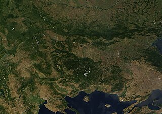
| Wa̱i a̱lyiat | Satellite image of the Balkan mountains (Stara Planina). The mountain range is running across the territory of Bulgaria. |
| A̱tyin | NASA, Image:Satellite image of Greece.jpg |
| A̱tyulyuut | User:Introvert |
| A̱wat (Á̱ bu shyia̱ di̱ nyia̱ ta̱m ma̱ng fail huni) |
Original image from NASA, cropped Image:Satellite image of Greece.jpg |
Shyiat kwaa̱mbwat a̱ka̱wat
| This file is in the public domain in the United States because it was solely created by NASA. NASA copyright policy states that "NASA material is not protected by copyright unless noted". (See Template:PD-USGov, NASA copyright policy page or JPL Image Use Policy.) | ||
 |
Warnings:
|
Nkhang fail
Nyap a̱tuk/jen a nwuan fail hu ma̱nang ku ku ndi di̱ ntsa hu mi̱ di̱n jen a̱ja.
| A̱tuk/Jen | A̱gban ghwughwu | Shi-a̱ka̱ta̱m | A̱tyunta̱m | A̱di̱dam | |
|---|---|---|---|---|---|
| mi̱ di̱ yong huni | 00:38, 22 Zwat Swak ma̱ng Sweang 2005 | | 2,379 × 1,671 (691 KB) | Introvert | {{Information| |Description=Satellite image of the Balkan mountains (Stara Planina). The moutain range is running across the territory of Bulgaria. |Source=NASA |Date= |Author=User:Introvert |Permission=Original image from NASA, cropped |other |
Nyian ta̱m ma̱ng fail
Wat huni nyia̱ ta̱m ma̱ng fail huni:
Nyian ta̱m ma̱ng fail mi̱ swanta hu a̱mgba̱m
A̱yaawuki á̱ghyang bani nyia̱ ta̱m ma̱ng fail huni:
- Nyian ta̱m di̱ arz.wikipedia.org
- Nyian ta̱m di̱ ast.wikipedia.org
- Nyian ta̱m di̱ az.wikipedia.org
- Nyian ta̱m di̱ ba.wikipedia.org
- Nyian ta̱m di̱ be.wikipedia.org
- Nyian ta̱m di̱ br.wikipedia.org
- Nyian ta̱m di̱ ca.wikipedia.org
- Nyian ta̱m di̱ ceb.wikipedia.org
- Nyian ta̱m di̱ ckb.wikipedia.org
- Nyian ta̱m di̱ da.wikipedia.org
- Nyian ta̱m di̱ eo.wikipedia.org
- Nyian ta̱m di̱ eo.wikiquote.org
- Nyian ta̱m di̱ eu.wikipedia.org
- Nyian ta̱m di̱ fr.wikinews.org
- Nyian ta̱m di̱ fr.wikivoyage.org
- Nyian ta̱m di̱ ga.wikipedia.org
- Nyian ta̱m di̱ ia.wikipedia.org
- Nyian ta̱m di̱ kab.wikipedia.org
- Nyian ta̱m di̱ ku.wikipedia.org
- Nyian ta̱m di̱ sv.wikipedia.org
- Nyian ta̱m di̱ tg.wikipedia.org
- Nyian ta̱m di̱ tt.wikipedia.org
- Nyian ta̱m di̱ vec.wikipedia.org
- Nyian ta̱m di̱ www.wikidata.org