
Fail:Igala.jpeg
Rezolushyon a̱ lan ma̱ng shi nshyia̱ bah.
Igala.jpeg (A̱yaapixel 579 × 374, shi fail: 165 KB, kak MIME: image/jpeg)
Nam-a̱lyiat
| Wa̱i a̱lyiat |
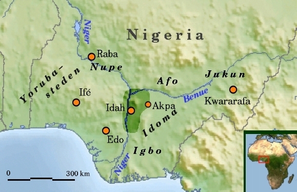
Nederlands: Historisch Igala in Nigeria, Nederlands |
| A̱tuk |
9 Zwat A̱taa 2008 (original upload date) |
| A̱tyin |
Transferred from nl.wikipedia; transfered to Commons by User:GijsvdL using CommonsHelper. |
| A̱tyulyuut |
Commons en Rollebon Original uploader was Rollebon at nl.wikipedia |
| A̱wat (Á̱ bu shyia̱ di̱ nyia̱ ta̱m ma̱ng fail huni) |
Released under the GNU Free Documentation License. |
Shyiat kwaa̱mbwat a̱ka̱wat

|
Á̱ shim konyan a̱ maat, ka̱u, a̱wot/ku a̱ shai dokumen jini a̱tafa nka̱nda̱n Kwaa̱mbwat A̱ka̱wat Saailyuut GNU Ma̱sa̱t hu, Nok 1.2 ku kuzang nok hwa ku cobai á̱zanson a̱ni nang á̱ shei mbwak Sotbeang Kyanglilyiit Ma̱sa̱t; di̱ mi̱n Ti̱tamm ji̱ Sang A̱gi̱gak a̱ni, di̱ mi̱n Lyuut A̱kup-Á̱son, a̱wot di̱ mi̱n Lyuut A̱kup-A̱ngaan meang. Á̱ mbeang maat kwambwat a̱ka̱wat nyiung mi̱ di̱ tamm ku shim a̱lyoot Kwaa̱mbwat A̱ka̱wat Saailyuut GNU Ma̱sa̱t a̱ni. |
| Á̱ nwuak fail huni a̱tafa kwambwat a̱ka̱wat Creative Commons Attribution-Share Alike 3.0 A̱sang-wa̱i hu hwa. | ||
| ||
| This licensing tag was added to this file as part of the GFDL licensing update. |
Original upload log
The original description page was here. All following user names refer to nl.wikipedia.
- 2008-06-09 19:41 Rollebon 579×374×8 (168600 bytes) {{Information |Description=Historisch Igala in Nigeria, Nederlands, nu met schaal |Source=ingetekend op http://commons.wikimedia.org/wiki/Image%3AAfrica_topography_map_with_borders.png en http://commons.wikimedia.org/wiki/Image:Africa_satellite_orthograph
- 2008-06-09 17:36 Rollebon 579×374×8 (175430 bytes) {{Information |Description=Historisch Igala in Nigeria, Nederlands |Source=ingetekend op http://commons.wikimedia.org/wiki/Image%3AAfrica_topography_map_with_borders.png en http://commons.wikimedia.org/wiki/Image:Africa_satellite_orthographic.jpg |Date=9-
Nkhang fail
Nyap a̱tuk/jen a nwuan fail hu ma̱nang ku ku ndi di̱ ntsa hu mi̱ di̱n jen a̱ja.
| A̱tuk/Jen | A̱gban ghwughwu | Shi-a̱ka̱ta̱m | A̱tyunta̱m | A̱di̱dam | |
|---|---|---|---|---|---|
| mi̱ di̱ yong huni | 00:06, 10 Zwat A̱taa 2008 | | 579 × 374 (165 KB) | File Upload Bot (Magnus Manske) | {{BotMoveToCommons|nl.wikipedia}} {{Information |Description={{nl|Historisch Igala in Nigeria, Nederlands}} |Source=Transferred from [http://nl.wikipedia.org nl.wikipedia]; transfered to Commons by User:GijsvdL using [http://tools.wikimedia.de/~magnu |
Nyian ta̱m ma̱ng fail
Wat huni nyia̱ ta̱m ma̱ng fail huni:
Nyian ta̱m ma̱ng fail mi̱ swanta hu a̱mgba̱m
A̱yaawuki á̱ghyang bani nyia̱ ta̱m ma̱ng fail huni:
- Nyian ta̱m di̱ arz.wikipedia.org
- Nyian ta̱m di̱ ca.wikipedia.org
- Nyian ta̱m di̱ de.wikipedia.org
- Nyian ta̱m di̱ en.wikipedia.org
- Nyian ta̱m di̱ es.wikipedia.org
- Nyian ta̱m di̱ fr.wikipedia.org
- Nyian ta̱m di̱ it.wikipedia.org
- Nyian ta̱m di̱ ja.wikipedia.org
- Nyian ta̱m di̱ lbe.wikipedia.org
- Nyian ta̱m di̱ mrj.wikipedia.org
- Nyian ta̱m di̱ nl.wikipedia.org
- Nyian ta̱m di̱ oc.wikipedia.org
- Nyian ta̱m di̱ pl.wikipedia.org
- Nyian ta̱m di̱ pt.wikipedia.org
- Nyian ta̱m di̱ ru.wikipedia.org
- Nyian ta̱m di̱ sr.wikipedia.org
- Nyian ta̱m di̱ uk.wikipedia.org
- Nyian ta̱m di̱ www.wikidata.org
- Nyian ta̱m di̱ yo.wikipedia.org