
Fail:The pathway of regional integration or separation.png

Shi nwuana̱son huni:a̱yaapixel 799 × 219 Ngyong ghyáng: a̱yaapixel 320 × 88 | a̱yaapixel 977 × 268.
A̱tsatsak fail (A̱yaapixel 977 × 268, shi fail: 18 KB, kak MIME: image/png)
Nam-a̱lyiat
| Wa̱i a̱lyiat |
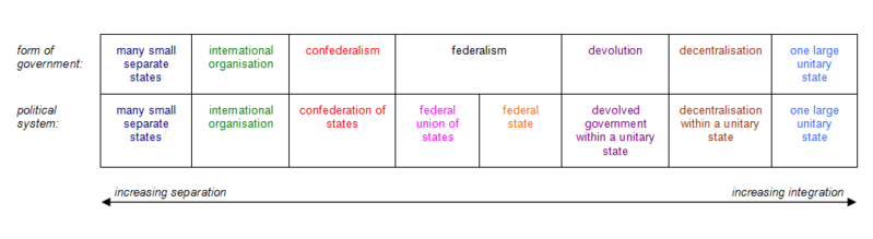
English: This diagram illustrates the various forms of government, and their associated political systems, located along the pathway of regional integration or separation. |
| A̱tuk | |
| A̱tyin | Law, John (2013) 'How Can We Define Federalism?', in Perspectives on Federalism, Vol. 5, No. 3, Figure 2 and Footnote XX, pp. E104, E116. |
| A̱tyulyuut | Federalunion |

|
File:The pathway of regional integration or separation.svg is a vector version of this file. It should be used in place of this PNG file when not inferior.
File:The pathway of regional integration or separation.png → File:The pathway of regional integration or separation.svg
For more information, see Help:SVG. |
Shyiat kwaa̱mbwat a̱ka̱wat
I, the copyright holder of this work, hereby publish it under the following licenses:

|
Á̱ shim konyan a̱ maat, ka̱u, a̱wot/ku a̱ shai dokumen jini a̱tafa nka̱nda̱n Kwaa̱mbwat A̱ka̱wat Saailyuut GNU Ma̱sa̱t hu, Nok 1.2 ku kuzang nok hwa ku cobai á̱zanson a̱ni nang á̱ shei mbwak Sotbeang Kyanglilyiit Ma̱sa̱t; di̱ mi̱n Ti̱tamm ji̱ Sang A̱gi̱gak a̱ni, di̱ mi̱n Lyuut A̱kup-Á̱son, a̱wot di̱ mi̱n Lyuut A̱kup-A̱ngaan meang. Á̱ mbeang maat kwambwat a̱ka̱wat nyiung mi̱ di̱ tamm ku shim a̱lyoot Kwaa̱mbwat A̱ka̱wat Saailyuut GNU Ma̱sa̱t a̱ni. |
Á̱ nwuak fail huni a̱tafa kwambwat a̱ka̱wat Creative Commons Attribution-Share Alike 3.0 A̱sang-wa̱i hu hwa.
- A byia̱ sa̱t:
- ka̱ a cat ka̱u – ka̱ a cat maat, ka̱u ma̱ng shei ta̱m hu
- ka̱ a cat nyia̱ ri̱mik – ka̱ a cat saai ta̱m hu
- A̱tafa ta̱fwat ji̱ khwi a̱ni:
- a̱di̱dam kaswuo – Ta hwa a nwuak a̱gwai ku myim a̱ni, tyia̱ a̱fwuop kwaa̱mbwat a̱ka̱wat ka, a si̱ wa̱i ka̱ á̱ ku shai kyang mami. A bye nyia̱ a̱nia di̱ kuzang za̱kwa ji̱ myim a̱ni, a̱wot tyong nyian hu si̱sak ji̱ na li á ngyei a̱tyunwuat kwaa̱mbwat a̱ka̱wat wu wa shim ang ku da̱ nggu wa shim nyian ta̱m ang hu a̱ni.
- ka̱u mameang – Ka̱ a nyia̱ ri̱mik, shai, ku a nok tazwa a̱ngga wu, ta hwa a ka̱u jhyet ang ji a̱tafa kwaa̱mbwat a̱ka̱wat ku yet kyang nyiung ku si̱ ku myim a̱ni nang a̱tsak wu.
A maai a khai kwambwat a̱ka̱wat hu nanɡ a cat a̱ni.
Nkhang fail
Nyap a̱tuk/jen a nwuan fail hu ma̱nang ku ku ndi di̱ ntsa hu mi̱ di̱n jen a̱ja.
| A̱tuk/Jen | A̱gban ghwughwu | Shi-a̱ka̱ta̱m | A̱tyunta̱m | A̱di̱dam | |
|---|---|---|---|---|---|
| mi̱ di̱ yong huni | 21:15, 31 Zwat Tswuon 2016 | 977 × 268 (18 KB) | Federalunion | Clarification to make fully consistent with forms at source reference. | |
| 13:19, 7 Zwat Tswuon 2016 | 966 × 266 (21 KB) | Federalunion | Even out column width (last column was too narrow, distorting the graphic). | ||
| 21:41, 25 Zwat Nyaai 2016 | 969 × 262 (17 KB) | Federalunion | {{subst:Upload marker added by en.wp UW}} {{Information |Description = {{en|This diagram illustrates the various forms of government, and their associated political systems, found along the pathway of regional integration or separation. [[:en:federali... |
Nyian ta̱m ma̱ng fail
Ngwat 2 nani nnyia̱ ta̱m ma̱ng fail huni:
Nyian ta̱m ma̱ng fail mi̱ swanta hu a̱mgba̱m
A̱yaawuki á̱ghyang bani nyia̱ ta̱m ma̱ng fail huni:
- Nyian ta̱m di̱ bn.wikipedia.org
- Nyian ta̱m di̱ ceb.wikipedia.org
- Nyian ta̱m di̱ en.wikipedia.org
- Nyian ta̱m di̱ it.wikipedia.org
- Nyian ta̱m di̱ jv.wikipedia.org
- Nyian ta̱m di̱ kn.wikipedia.org
- Nyian ta̱m di̱ ne.wikipedia.org
- Nyian ta̱m di̱ sd.wikipedia.org
- Nyian ta̱m di̱ sq.wikipedia.org
- Nyian ta̱m di̱ sr.wikipedia.org
- Nyian ta̱m di̱ ta.wikipedia.org
- Nyian ta̱m di̱ tr.wikipedia.org
- Nyian ta̱m di̱ vi.wikipedia.org
- Nyian ta̱m di̱ yo.wikipedia.org