Khwong Jenshyung
| Yet kap | Pa̱la̱sti̱n (a̱byin), occupied Palestinian territories, Israeli-occupied territories, Middle East, A̱siya Jenshyung |
|---|---|
| Kpaat | 1949 |
| Kap | Israeli–Palestinian conflict |
| A̱lyoot da̱ a̱lyem mbyin | الضِّفَّةُ الْغَرْبِيَّةُ |
| Vocalized name | الضِّفَّةُ الْغَرْبِيَّةُ |
| A̱lyoot da̱nian | jenshyung |
| Demonym | cisjordà, cisjordana, cisjordans, cisjordanes |
| A̱lyem a̱gwomna̱ti | La̱ra̱ba |
| Vam-a̱byin | A̱siya |
| A̱byin | Pa̱la̱sti̱n (a̱byin) |
| A̱keangtung | Ramallah |
| Shyia̱ di̱ fam tyok a̱byin | Pa̱la̱sti̱n (a̱byin) |
| Shyia̱ di̱ fam jen | UTC+02:00, UTC+03:00 |
| A̱vwuo | Southern Levant |
| Shyia̱ mami ku kpa̱mkpaan vam a̱sa̱khwot | Dead Sea, Jordan River, Sea of Galilee |
| Located in/on physical feature | Palestine |
| Territory claimed by | Pa̱la̱sti̱n (a̱byin), Isi̱rela, Urdun |
| Coordinate location | 32°0′0″N 35°21′0″E |
| Coordinates of easternmost point | 32°12′41″N 35°34′25″E |
| Coordinates of northernmost point | 32°33′7″N 35°13′29″E |
| Coordinates of southernmost point | 31°20′32″N 34°55′27″E |
| Coordinates of westernmost point | 31°23′31″N 34°52′48″E |
| Highest point | Mount Nabi Yunis |
| Lowest point | Dead Sea |
| A̱kwak a̱son a̱gwomna̱ti | Mahmoud Abbas |
| Kurum | new shekel |
| Byia̱ (a̱gi̱)gak ma̱ng | Isi̱rela, Urdun, Green Line |
| Shyia̱ dundung ma̱ng | Judea and Samaria Area |
| Present in work | West Bank Wall graffiti art |
| Hashtag | westbank |
| Nkhang | History of the West Bank |
| Köppen climate classification | hot-summer Mediterranean climate |
| Zwunzwuo-a̱muup yei a̱byin | +970 |
| Byia̱ lyulyoot | list of Israeli settlements |

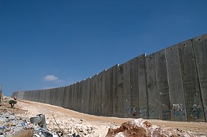
Khwong Jenshyung hu (La̱ra̱ba: الضفة الغربية, romanized: aḍ-Ḍiffah al-Ġarbiyyah; A̱biru: הגדה המערבית, romanized: HaGadah HaMaʽaravit, nang á̱ghyang á̱niet mi̱ Isi̱rela ka ngyei A̱biru: יהודה ושומרון, lit. 'Yahuda ma̱ng Sa̱mariya' a̱ni)[1][2] yet fam a̱byin hwa nang bibyin ghyáng keang di̱ tityak kpa̱mkpaan khwong Meditaroniya hu di̱ fam A̱siya Jenshyung ku yet kap ku swak ma̱ng shi hu mi̱ bibyin Pa̱la̱sti̱n hu a̱ni.[3] Ku byia̱ a̱gi̱gak ma̱ng a̱byin Urdun ma̱ng Kyai A̱sa̱khwot ku Sang Swuan hu di̱ fam a̱tyin hu a̱wot ma̱ng Isi̱rela (nwuan Lang Lyilyim) di̱ nfam a̱tak, jenshyung, ma̱ng a̱za hu.[4] A̱tafa tyok a̱khwot á̱kwop Isi̱rela neet ma̱ a̱lyia̱ 1967, á̱ ka̱u a̱vwuo ka di̱ "bibyin a̱ka̱wa̱tyia̱ a̱byin" Pa̱la̱sti̱n 165 ku shyia̱ tafa kwak a̱son Atoriti A̱byin Pa̱la̱sti̱n (PNA) wu ku di̱n kap ku ma̱ a̱gba̱mgbam, mbeang a̱ka̱keang Isi̱rela 230 da̱nang ncam Isi̱rela shyia̱ di̱ cobai da̱ nna a̱ni. Khwong Jenshyung hu ka mbyia̱ Urusha̱lima A̱tyin.
Ya̱fang
[jhyuk | jhyuk a̱tyin ka]- ↑ Karayanni, Michael (2014). Conflicts in a Conflict. p. xi.
- ↑ רוזנפלד, שאול; אופנהיימר, יריב (2010). "המהפך של נתניהו". ynet.
ההיסטוריים והאידיאולוגיים שנכרכו עם השנים במונחים גדה מערבית ויהודה ושומרון
; Ginges, Jeremy, and Scott Atran. "Sacred values and cultural conflict." Advances in culture and psychology 4 (2013): 278–279. quote: Notwithstanding its abstractness, to religious settlers many of the more significant places that they lay claim to—from the old city of Jerusalem to the "Cave of the Patriarchs" (Me’arat ha-Machpela)—are in what the rest of the world calls the West Bank but what they refer to as Yehuda VeShomron. - ↑ "West Bank", The World Factbook (in English), Central Intelligence Agency, 2022-09-27, retrieved 2022-09-30
- ↑ Ghyuap di̱n tyan: Invalid
<ref>tag; no text was provided for refs namedCIA

